
 2 hours ago
Satellite images, scientific studies and project reports had been signalling trouble long before the collapse.
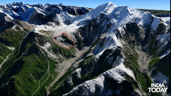
Enhanced 3D image of the site of glacial collapse

New Delhi,UPDATED: Sep 3, 2026 19:18 IST
Many questions remain in the minds of people after the catastrophic disaster in Nepal that claimed hundreds of lives.
But one sits at the centre of it all.
Was there really no way to predict it? No warning? No signs? Nothing that could have helped reduce the scale of the devastation?
What if we told you the clues were already out there—in the open source?
Dozens of reports. Satellite images. Scientific studies. Expert observations. All pointing to risks that had been building long before the disaster struck.
Don’t take our word for it.
India Today’s OSINT(Open-source Intelligence) team pieces together statements and observations from experts and climatologists, along with published research and satellite evidence, to visually establish the warning signs that were already hiding in plain sight.
WARNING SIGN 1: ACCELERATING GLACIER SURFACE
Geophysicist Manoochehr Shirzaei detected displacement of nearly 10 mm per month in the glacier–rock system near the disaster’s source. Images from the final weeks suggest that a section of the glacier, along with the rock beneath it, was accelerating before the collapse—an indication of an increasingly unstable system.
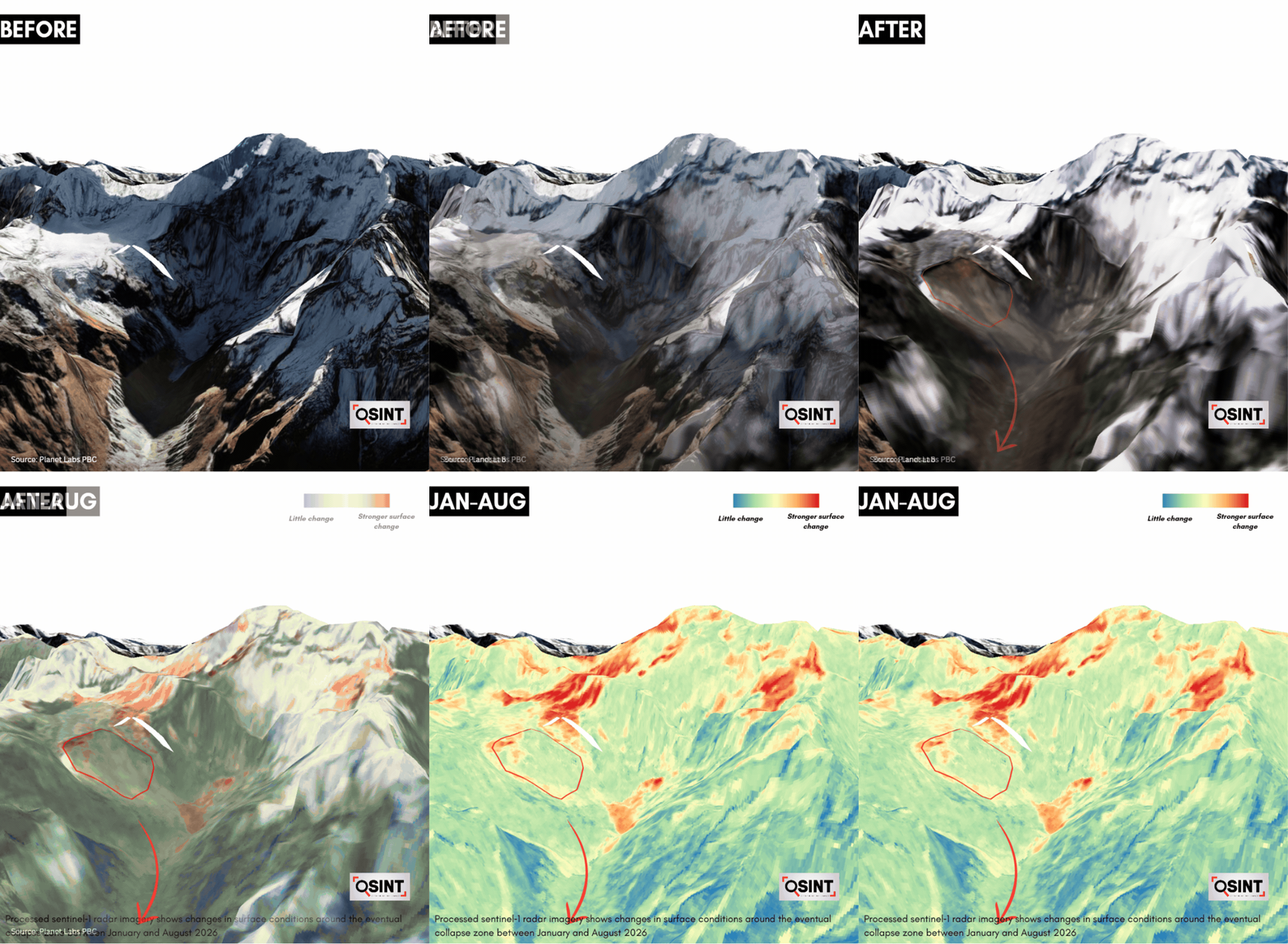
India Today’s change-detection analysis also found surface changes around the exposed rock outcrop. The results show the strongest temporal-change signal in this area, broadly consistent with the zone of instability identified in Shirzaei’s assessment.
Further evidence comes from NISAR, the joint NASA–ISRO radar satellite. Researcher Zhenjiang Liu’s analysis of imagery between June 20 and August 19 detected metre-scale cumulative movement near the source of the avalanche. The deformation was concentrated on the steep slope that later failed, indicating that the terrain had been shifting for weeks before the disaster.
WARNING SIGN 2: BROWN MELTWATER, BEDROCK CRACKS AND TEMPERATURE ANOMALY
A HiRISK Rapid Hazard Assessment, prepared by an international team including researchers from the Stimson Center, the Asian Mountain Academic Alliance and China’s Institute of Mountain Hazards and Environment, identified several pre-event indications in satellite imagery. By August 24, meltwater near the eventual failure zone had turned visibly brown, while imagery from the days before the disaster also showed indications of a crack propagating into the surrounding bedrock slope. The assessment cautions that these signs were identified in hindsight and did not amount to a real-time prediction of the collapse.
The assessment also cites ERA5—a global climate dataset combining observations with atmospheric modelling—which shows above-average temperatures near the failure site during the preceding month. While acknowledging the limitations of estimating conditions at such a remote location, the report says “unusual warmth may have intensified melting and contributed to the failure.”
India Today could not independently verify these specific pre-collapse indicators from the material available.
WARNING SIGN 3: SUDDNE LOSS OF SNOW
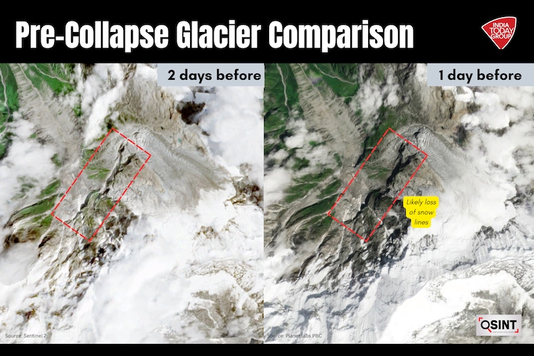
Geomorphologist Dan Shugar of the University of Calgary observed that Planet Labs imagery appeared to show substantial snow loss across some glaciers in the 24 hours preceding the disaster.
To examine this observation, India Today compared satellite imagery captured in the days leading up to the disaster. Despite differences in spatial resolution between the August 24 Sentinel image and the August 25 image by Planet labs PBC, a careful comparison showed that snow cover visible along one side of the slope was largely absent by August 25.
The finding supports Shugar’s observation of rapid snow loss in the upper catchment.
This suggests that rapid snowmelt in the upper reaches may have added to the volume of flood that swept through Rasuwagadhi and surged into the Bhote Koshi–Trishuli river system.
WARNING SIGN 4: DPR REPORTS
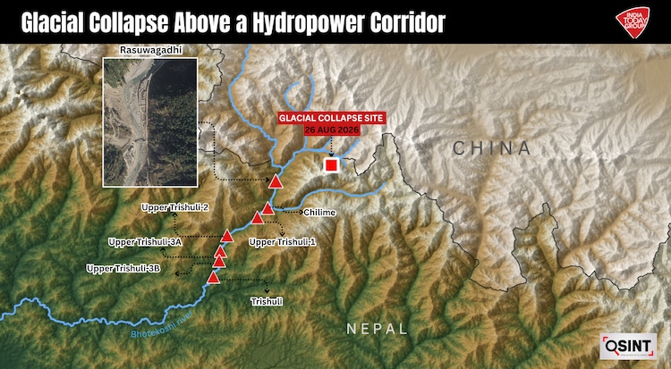
At least seven hydropower projects sit along the Trishuli river corridor, and their own engineering studies, DPRs, climate assessments and operational records repeatedly flag the same underlying vulnerabilities.
At Rasuwagadhi, engineers surveying damage after the 2015 Nepal earthquake found that rockfalls had already diverted the river, breached a temporary cofferdam and flooded the project headworks.
At Chilime, the operator described the slope beside its Syafrubensi colony as progressively unstable and posing “high risk” to buildings and the settlement below, while later reports record recurrent monsoon inundation threatening the Bremdang Khola. A geological study for Upper Trishuli-2 found its headrace alignment crosses two faults and classified much of the rock mass as poor to fair.
The warnings become sharper farther down the cascade. Upper Trishuli-1's climate-risk assessment identified increasing extreme streamflows, changing snow and glacier melt, sedimentation and landslides as threats to the project. In its own engineering assessment the project was described as “climate proof”, its project framework nevertheless required emergency preparedness and response plans.
The warnings become sharper farther down the cascade. Upper Trishuli-1's climate-risk assessment identified increasing extreme streamflows and floods, changes in rain, snow and snowmelt, sedimentation and landslides as potential risks to the project. The Upper Trishuli-3B DPR identified about 117 glacial lakes in the Trishuli catchment and recommended glacier-lake monitoring; the same DPR warned that Glacial Lake Outburst Flood(GLOFs) can carry unusually high sediment and debris loads and exceed conventional extreme-flood assumptions.
Taken together, these assessments point to a persistent gap in early-warning preparedness across the Trishuli hydropower corridor. The HiRISK assessment specifically notes “no operational EWS(Early Warning System) was set up in this place for glacier-related hazards”. It goes on to add that if “warning times of 10 minutes or more were available”, then a comprehensive and well-equipped warning system could have saved a significant number of lives.
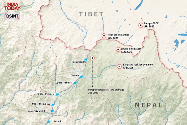
The August 2026 disaster struck a river corridor with a documented history of glacier-related floods and rock-ice avalanches stretching back decades including a previous drainage of the same Purepu glacier system in 2023 and a catastrophic GLOF incident only 13 months earlier.
- Ends
Published By:
bidisha saha
Published On:
Sep 3, 2026 19:18 IST